As much as Niantic might be focused on making its location-based games more playable at home, it's also thinking about its future. The developer has bought 3D mapping startup 6D.ai to help it develop "planet-scale" augmented reality. Th...
A couple of weeks ago we checked out ETH Zurich Autonomous Systems Lab’s walking robot that had a drone launching pad. That combos nicely with one of the Lab’s latest projects: a similar pair working together to navigate unknown terrain.
The hexacopter drone has a camera that lets it scout ahead, making an elevation map of its surroundings as well as noting landmarks. Its companion walking robot uses that data to plan its path on the fly. It also has sensors to keep its balance and avoid obstacles.
Now all they need is a robot Mumbo Jumbo that can mod them into different forms as needed. As long as they have enough tokens to pay him.
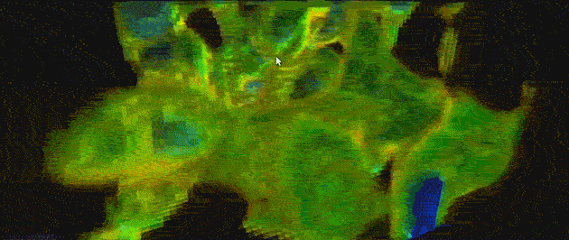
If you’re old enough to remember CRT TV’s with the big bunny ear antennas, you’re likely to understand how easily radio signal strength can be affected by even a tiny move of the receptor. A similar principle applies to WiFi signals, and the above visualization drives the point straight home. It’s a 3D map of YouTuber CNLohr‘s WiFi signal in his home, albeit that of the relatively small area (360x360x180mm) within his CNC mill. See, to get this done he hooked up a ESP8266 WiFi module to his laptop, which gave him signal strength in real-time at 500Hz. He then mounted the module inside a large gantry-style cnc mill and took several long exposure shots, which he then composited in Voxeltastic, [CNLohr’s] own HTML5/WEBGL based render engine. The results can be seen above, and although it looks completely organic, it follows a pattern: “the signal strength increases and decreases in nodes and anti-nodes which correspond to the 12.4 cm wavelength of a WiFi signal.” And it also goes to show that if you’re having problems with reception, you might want to consider just moving your router a tiny bit before you start cursing it.
Like any tool, 3D printers can’t magically produce the thing you want on its own. You have to provide detailed instructions to the machine in the form of a 3D model, which of course requires training and studying to master. But drawing a sketch is something that pretty much anyone can do. So Tangible Solutions came up with Pango, a service that will turn sketches into 3D models.
To use Pango, you first have to get a special sketchbook that Tangible Solutions calls the Inventor’s Notebook. You’ll use the notebook to first make a rough sketch of your model, then draw more detailed and multi-perspective illustrations and finally a write a brief description of what you want to make.
You’ll then use a mobile app to take a picture of your sketches, drawings and description and send those pictures to Tangible Solutions. They will then send back a 3D model based on your input. As shown in the topmost image, the app shows you the 3D model using augmented reality. When you receive your 3D model, you can point your mobile device over your sketches and the 3D model will pop out on the screen directly over your sketches. It’s a great way to show how your two-dimensional drawings were translated into 3D.
After you’ve seen your 3D model, you can send additional input to Tangible Solutions and have them tweak the model if you want. If you’re happy with what you saw the company can print the model and ship the 3D printed object to you.
Pledge at least $99 (USD) on Kickstarter to receive the Inventor’s Notebook and have access to the augmented reality feature when the service goes live. As someone who doesn’t know how to use 3D modeling software I don’t want to dismiss Pango off the bat. I’m just not sure if this is the most elegant or convenient way for folks like me to take advantage of 3D printing. First of all, while your initial sketch may be rough, you’ll still have to make a good final drawing, otherwise you might spend a lot of time going back and forth with Tangible Solutions discussing your concept. I’m not sure the kids in the video could have gone through the steps on their own. Also, I think Pango is for people who want to make 3D models or 3D printed objects occasionally. If 3D printing is essential you to your business or hobby, you might be better off learning how to make 3D models or at least hiring a 3D modeler directly. Finally, I hope Tangible Solutions will give their customers a way to export their 3D models so that they can have it printed somewhere else.
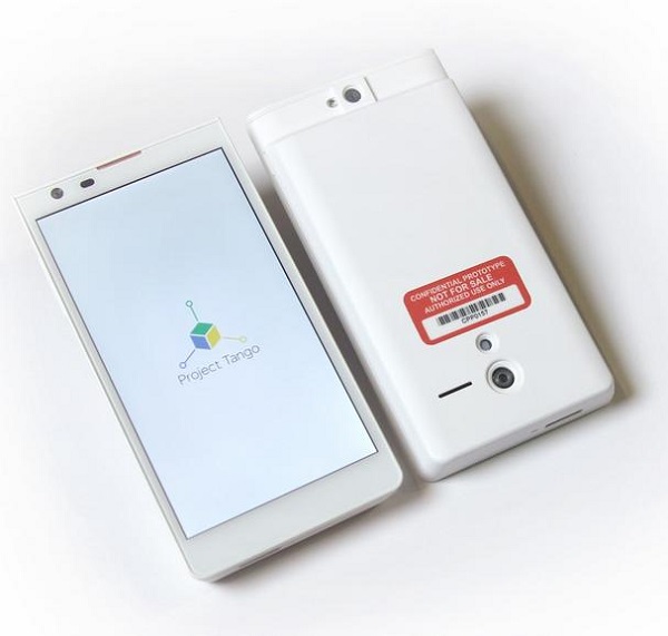
Google’s Advanced Technology and Projects group (ATAP) recently unveiled Project Tango, a smartphone that lets users make 3D models of their surroundings. ATAP is also working on development APIs that will let developers use those 3D models in apps.
The current Project Tango prototype is a 5″ phone with a 4 megapixel camera, a depth sensor, a motion tracking camera and two “computer vision processors.”
The sensors supposedly take about 250,000 measurements per second, which the phone processes into a 3D model in real time.
You’re not going to let the Google Street View crew into your house, but a harmless little smartphone? Come to my pocket and my life! The NSA wants a pendant-sized version of this thing yesterday.
Project Aria wasn’t the only reason why Google insisted to keep Motorola Mobility’s employees when handing over this company to Lenovo. At the time, they were also involved in creating Project Tango, a smartphone capable of 3D mapping the physical world.
This revolutionary smartphone has a lot of useful applications, including capturing the dimensions of a house prior to purchasing furniture, mapping buildings to avoid getting lost in them, creating directions to new locations that are more accurate than just street-level. All in all, Project Tango is a great experiment with space and motion, and intends to give mobile devices a human-scale understanding of these notions. It should be noted that unlike Google X projects, which are kept in great secret most of the time, this experimental smartphone is launched with an invitation for software developers to come help Google build it faster.
Johnny Lee, head of the ATAP (Advanced Technology and Projects) team, pointed out that this 3D mapping smartphone is the result of a collective effort: “Over the past year, our team has been working with universities, research labs, and industrial partners spanning nine countries around the world to harvest research from the last decade of work in robotics and computer vision, concentrating that technology into a unique mobile phone. Now, we’re ready to put early prototypes into the hands of developers that can imagine the possibilities and help bring those ideas into reality.”
Project Tango is a 5-inch smartphone that packs custom hardware and software needed for tracking the full 3D motion of the device. More precisely, the prototype phone comes with a 4 MP camera, a motion tracking camera, an integrated depth sensor and two computer vision processors. The entire assemble can easily map the surrounding environment for future use in various contexts. As the sensors collect 250,000 3D measurements every second, accuracy is the least of the problems for this prototype.
At the moment, there are only 200 prototype dev kits that Google is looking to share with professional developers. The future collaborators will make experiments either in indoor navigation or single and multiplayer games that use the surrounding environment. By March 14th, 2014, Google intends to get rid of all the dev kits, so if you happen to have an idea about how the 3D mapping smartphone could be used, don’t hesitate to fill in the form available on the Project Tango page.
Google wanted to stress that while this smartphone runs Android, the 3D mapping technology and the software used for collecting data from the sensors is not yet part of this mobile OS, and it may take a while till it becomes so.
Roboray is the latest humanoid robot created by Samsung’s Advanced Institute of Technology. Using visual recognition software developed by a team University of Bristol, the ‘bot can now build real-time, 3D visual maps of its environment. It basically looks at its surroundings and creates a map of them as it moves. This also allows it to remember where it has been before.
Roboray also walks like a real person. Where most humanoid robots walk by bending their knees to keep their center of mass constant, Roboray falls a little bit with each step, which is how we walk.
Between mapping it’s own environment and walking just like us, it won’t be long before robots are walking among us on the streets. After that they will easily disguise themselves as humans and really give us a reason to be scared.
Google's 3D City View is now available on iOS. The Google Earth update adds three-dimensional imagery to major locations including Washington D.C, San Francisco and Boston. It's arriving alongside Tour Guide; select a notable attraction to go straight to it, with accompanying trivia you can bore your friends with later. Sadly 3D maps requires the processing hardware of the iPhone 4S, iPad 2 or the third-generation iPad, but other iOS (4.2 or higher) device users can still get access to Tour Guide. Unsurprisingly, the update's available via the App Store -- but you shouldn't need a map to find your way there.
Switzerland's EPFL has managed to catch our attention with its various UAV-related activities, and it looks like it's also been the radar of Parrot, maker of the AR.Drones. EPFL announced today that the French company is investing 7.4 million Swiss Francs (or about $7.5 million) in two companies that have been spun out of the institution: senseFly and Pix4D. As you may recall, those two have collaborated in the past, with senseFly providing the camera-equipped UAVs necessary for Pix4D's 3D mapping software. Broken down, the investment works out to 2.4 million Francs put into Pix4D and five million invested in senseFly, the latter of which is enough for Parrot to claim a majority stake company. As for the future, senseFly's CEO says that the deal will give Parrot "access to the expertise and the technology for specialized drones," while Pix4D's CEO says that the investment "reinforces our position as a leader in software for professional drones" and opens up new business opportunities. It also makes it clear, if it wasn't already, that Parrot is getting pretty serious about drones. You can find the official announcement after the break, along with a video from EPFL explaining the deal.
The mapping scene has seen plenty of activity lately -- what with Apple ditching Google to launch its own service while the latter continues to layer on improvements such as better walking directions and more Street View coverage for its maps. Now a new app called "Recce" is trying to elbow its way into the conversation by using a free, searchable 3D mapping system that not only serves up location-based services but also location-based games. Named after military slang for "reconnaissance," Recce is the brainchild of former Psygnosis co-founder Ian Hetherington and Google engineering director Rian Liebenberg, who formed London-based developer eeGeo. The app works by pulling together a slew of data feeds from sources such as map providers and social networking services to provide an interactive 3D view of an area. It can also be used to update services like Twitter so your followers can know exactly where you were when you saw Justin Johnson, er, Bieber speeding away from the paparazzi in his chrome Fisker Karma. Do note that data is limited to central London at the moment, though San Francisco and New York are slated to get their 3D closeup next.
 As much as Niantic might be focused on making its location-based games more playable at home, it's also thinking about its future. The developer has bought 3D mapping startup 6D.ai to help it develop "planet-scale" augmented reality. Th...